Wednesday 15th February 2012
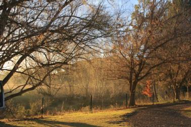
We left home this morning and made our way south over the Gateway Bridge and on through the Gold Coast until we reached our destination of the Pottsville South Holiday Park. This park is on the banks of the Mooball Creek and just a short stroll to Pottsville Beach which stretches up to Hastings Point to the north. Enjoyed a week of R & R, walking on the beach, swimming and took a couple of drives north to Hastings Point, Kingscliff, Fingal Point and south to Brunswick Heads. Anita and Scott joined us for the weekend. Hot, summery weather and a couple of storms. Very nice spot.
22nd February 2012.
Moved on to Woody Head campground in Bundjalung National Park just north of Iluka. Only here for a couple of days but very enjoyable. Beaches to walk along but also a large rocky beach where we spent hours exploring the rock pools. Stormed each night we were here.
24th February 2012.
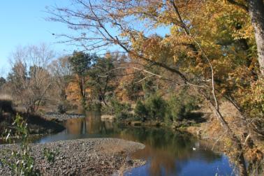
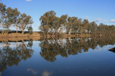
Packed up and moved all the way to Iluka to Riverside Caravan Park on the banks of the Clarence River. A lovely spot. We played golf, went for a bike ride and took a ferry ride to Yamba. Visited Back Beach, Iluka Bluff and Iluka Beach. Also went for a drive to Brooms Head, Minnie Water, Sandon and Wooli all in the Yuraygir National Park. Enjoyed some of the local seafood - fish and prawns. Very hot weather but not much rain.
2nd March 2012.
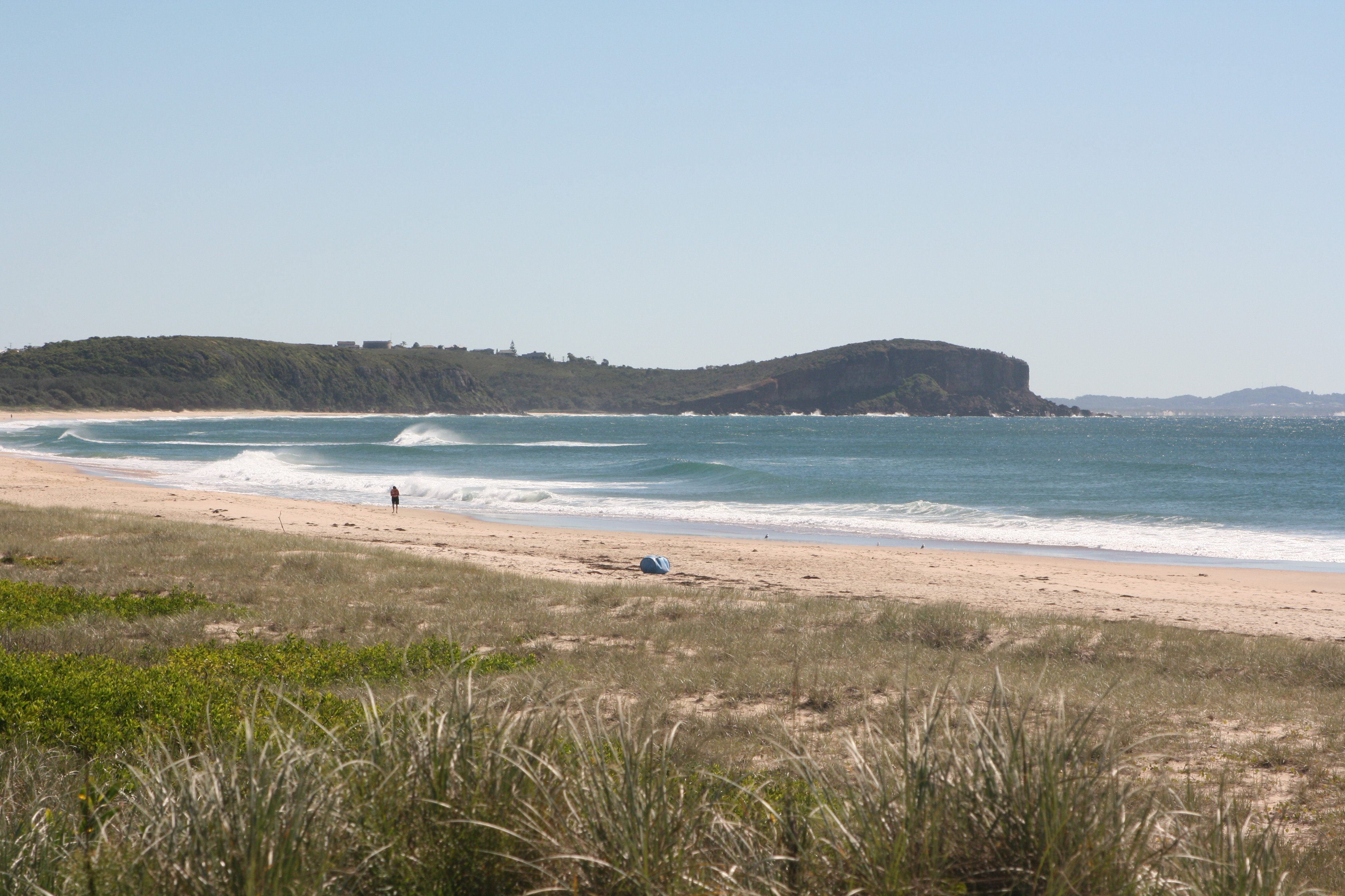
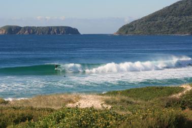
Our next stop was Corindi Beach about 40 km north of Coffs Harbour. The weather was nice when we arrived and set up camp with a nice view of the coast. Didn't take long to change and for the wind, cloud and rain to come in. However, there were enough fine periods for us to go walking and to take a couple of drives. We went into Coffs Harbour to replenish supplies, visited Red Rock and took an inland drive to Glenreagh, Nana Glen, Coramba, Karangi and up to Sealy Lookout which gives outstanding views over Coffs, banana plantations and the coast both north and south. Russ was brave and went nearly to the end of the cantilevered lookout. Also called in to the seaside villages of Arrawarra, Woolgoolga (nice views) and Moonee Beach.
9th March 2012.
Moved all the way to Urunga - once again on the river bank (this time the Kalang and Bellinger Rivers) and only a kilometre walk out on the boardwalk to the ocean. Very impressed with Urunga - a sleepy little town but the boardwalk over the lagoon was very impressive - walked out there several times and fed the fish and birdwatched. Took a drive up the mountain via the waterfall way to Bellingen and Dorrigo and visited Dangar Falls and Griffiths Lookout near Dorrigo and went bushwalking in the National Park. Had to take a drive into Coffs for new car batteries and took the scenic way home via Repton and Mylestom. Played golf at Urunga and took a day trip into Nambucca Heads for sightseeing and played golf on the island there as well. On the way there called into Valla Beach (not impressed) and Nambucca is looking a little tired.
16th March 2012.
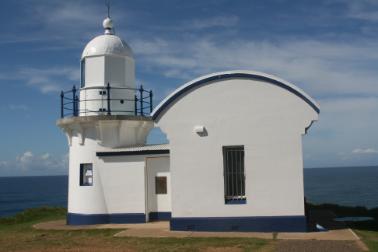
Our next stop was South West Rocks/Arakoon. Once again the beaches are beautiful. Took a day trip to Smoky Cape Lighthouse and walked down to Smoky Bay - one of many secluded little bays in Hat Head National Park. Also visited the ruins of Trial Bay Gaol where prisoners were housed in the late 19th century to build a breakwater for safe anchorage for ships which turned out to be a spectacular failure (as quick as it was built it was washed away). It was then abandoned until 1914 when it was used as an internment camp for Germans during the first world war. It was then abandoned again and all the fittings were sold off so all that remains are the thick granite walls. Very beautiful spot and a lovely view from up the top near the German Monument (which has been rebuilt after being blown up in 1919). South West Rocks is an interesting little place with an informative museum housed in one of the old boatmens cottages which details a lot of the shipwreck and boatmen history around this coast. The weather wasn't great but enjoyed quite a few games of table tennis, walking, swimming and bike riding. Also went into Kempsey and came home via Crescent Head and Hat Head.
23rd March 2012.
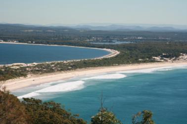
Our next stop was North Haven just north of Laurieton. The amount of water (rivers, lakes etc.) is amazing and there is a great view from North Brother Lookout where the hang gliders take off from. Went for a drive to Dunbogan and up to Charles Hamey lookout. Also spent a day at Timbertown at Wauchope - very interesting displays and being a weekend the steam driven sawmill was working as well as bullock team and steam train. Came home via Byabarra, Comboyne and down through the backblocks of Lorne. Went for a drive to Taree and Wingham (worst roads in NSW) and then home via Harrington and Crowdy Head where we visited the lighthouse. Also went for a drive to Diamond Head, Indian Head and Kylie's Beach in Crowdy Bay National Park (nice campground at Diamond Head) and we walked out to the headland there (the wildflowers were just finishing - they would have been quite spectacular). Then came back to Dunbogan and walked out to Perpendicular Point (nice vantage point in whale season). Also drove to Bonny Hills and Rainbow Beach (very nice). North Haven was a great spot for bike riding - flat and miles of bike tracks, and we also enjoyed a game of golf at Kew.
30th March 2012.
Time to move on and this time we backtracked a little and came back to Port Macquarie via Bonny Hills and Lake Cathie. Accommodation was at a premium because of Easter and school holidays so it was a matter of where we could find somewhere to stay and not be travelling over Easter. Saturday night we went up to Kempsey and caught up with Scott who was working there. Port Macquarie has lots of beaches and a quite spectacular walk from town to Tacking Point lighthouse and Lighthouse beach about 10km one way. We did the walk in various sections over a few days and it was most enjoyable. Also went for a sunset fish and chip cruise on a chinese junk up the river and into some of the canal estates. Port Macquarie has quite a bit of history as it was the third coastal settlement in NSW, established as a convict settlement in 1821. Visited the glasshouse and some historical sites around town and went exploring through the old cemetery and then went walking along Kooloonbung Creek where the flying foxes have taken up residence.
11th April 2012.
Moved on to Gloucester as Easter was over although still NSW school holidays. Camped on the banks of the Gloucester River and went walking through town and also the Boomerang walk along the banks of the river and through the parks. Drove out through Barrington to Copeland Tops and down through Rawdon Vale (where Australia's most wanted was captured) and up to the Gloucester River campground. Went out for tea at Country Club with Stuart and Tamara. The next day we drove out to their place at the end of Buliac Road via the Kia Ora lookout - wound around about 5km of goat track so we couldn't take the van out there. Very impressive property with about 400 head of cattle and looks a picture at the moment. Stayed the night as we didn't want to tackle the goat track in the dark and a very enjoyable time was had by all. Returned to Gloucester and explored the rest of the town and went for a drive around the Buckets (mountains). Gloucester is a pretty little town with a lot of history - first explored in 1826 and then taken up by the AA Company.
15th April 2012
Packed up and on our way again through Stroud Road and Dungog and on to Clarence Town. Another very old town which was first explored in 1801. A ship building industry was set up here and Australia's first ocean-going steamship was built here and launched in 1831. Went for a drive to Stroud which was founded in 1824 by the AA Company. There are many historic buildings in town dating from the 1830's and an old cemetery. Also visited the underground convict built grain silos - an innovative idea to keep the grain safe from insect attack. Drove on to Dungog which once again dates back to the early 1800's. Most of the main street buildings are quite old and have a plaque detailing their history placed on the front. The weather turned nasty so we headed home after pies from the bakery. After a couple of days of ordinary weather decided to go for a drive to Chichester Dam and Barrington Tops NP and home via the old towns of East Gresford, Vacy and Paterson. Using Clarence Town as a base we then went on a day trip to Raymond Terrace past Williamtown and out to the southern side of Port Stephens visiting all the little beachside towns like Lemon Tree Passage, Anna Bay, Fingal Bay, Soldiers Point and Nelson Bay. Went up to Gan Gan lookout at Nelson Bay (lots of Gymea Lillies flowering) and also visited the museum and lighthouse (which wasn't really a lighthouse). Because of all the rain there was water lying around everywhere and all the places seemed to be a little tired.
23rd April 2012.
Time to move again and this time we backtracked a little again and moved north to Forster which we had missed because of the Easter holidays. Very impressed with the twin towns of Tuncurry/Forster - beautiful views, nice beaches and very neat and tidy towns. The weather turned cool and wet again but managed to do quite a bit of walking - along the coast to One Mile Beach and over the bridge into Tuncurry. Also went for a drive along the coast up to Hallidays Point, Diamond Beach and Old Bar. Another day was spent on a drive out to the lookout at Cape Hawke, then down past Seven Mile Beach, through Booti Booti National Park to Smiths Lake and then to Seal Rocks and the Lighthouse at Sugarloaf Point. We spent the rest of our time walking, bike riding, playing golf and generally just enjoying retirement.
7th May 2012.
On the road again and we moved all the way to Hawks Nest on the northern shores of Port Stephens. Small holiday settlement and the crowds have mostly disappeared. The beaches are beautiful but too cold for swimming. Walked along the beach and climbed up on Yacaaba Headland for some great views. Also went for a drive into Myall Lakes National Park through Mungo Brush visiting lots of little camping and picnic areas and went walking at Mungo Brush. Drove as far as the ferry at Bombah Point which you can catch across to Bulahdelah but it had broken down. Took the ferry from Tea Gardens across to Nelson Bay - the weather was perfect and had a great day. Also played golf at the Hawks Nest course - a picture perfect course and tougher than it should have been. Went bike riding to Jimmys Beach and Winda Woppa but the wind had picked up and it was hard work.
14th May 2012.
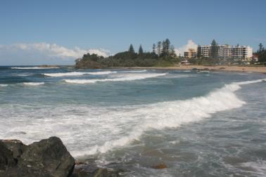
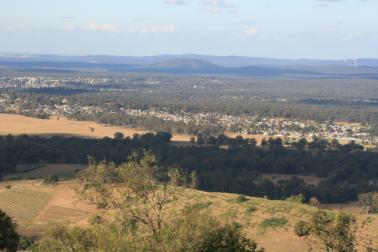
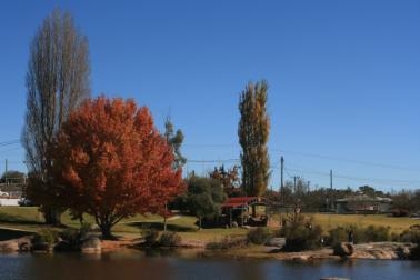
It was time to move inland and so we moved to Cessnock in the Hunter Valley. Went for a drive around some of the vineyards and up to Bimbadeen lookout. The next day we went on an organised wine tour visiting Sobels Winery, Audrey Wilkinson Vineyard, Tullochs Wines, Lamlock Vineyard as well as Polkobin Olive Centre (yummy), the Smelly Cheese Shop and the Chocolate shop. It was very interesting and we learnt a lot and are now wine conisseurs!!!!! A beautiful area with all the autumn colours and lots of money tied up here The next day we played golf with our neighbours in the park at Stonebridge just across the road from the park. It took us all day even with a cart - very challenging and the distance between holes was ridiculous but a good time was had by all.
17th May 2012.
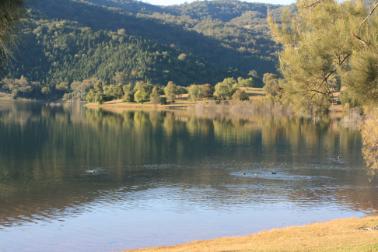
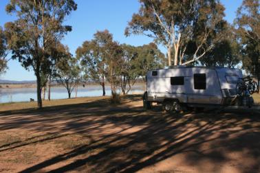
Today's journey took us through Singleton, Muswellbrook and Aberdeen past coal mines and power stations to Lake Glenbawn about 15km from Scone. Our camping spot was on the lake's edge (which was full) and a perfect place for a few days. No power or drinking water but hot showers and toilets and lots of bird and animal life. Very quiet until the weekend when ski boats and people arrived. Went for a drive to the Upper Hunter vineyards through Sandy Hollow and Denman. This area is not nearly as commercialised as the lower Hunter and although there are quite a few vineyards there are not nearly as many cellar doors. The Scone horse festival had been on for the last couple of weeks and the grand finale on Sunday was the Scone School had a fete at the lake finishing with a fireworks display. What a great display and we had a ringside seat (maybe they were aiming at us).
21st May 2012.
Left Lake Glenbawn and travelled via Scone, Wingen and Murrurundi to Nundle. What a pretty little place (very like NZ with autumn colours, shallow babbling creeks and old buildings). The first couple of mornings were frosty (frozen water pipes) and then beautiful sunny days. Went driving to Bowling Alley Point, Chaffey Dam and then up to Chawneys Pass on the top of the Great Divide at a height of 1175 Metres via Teamsters Rest camping area. While the weather was good continued to explore the area visiting Hanging Rock lookout (great views), the cemetery where Mary Ashton (of Ashtons Circus) was buried in 1852, the village of Hanging Rock, the Sheba Dams which were constructed by the gold miners and the Arc en Ciel Trout farm which is on the eastern slopes of the Great Divide. Reached a height of 1250 metres along the top. Went walking around town, visited the Nundle Woollen mill (part of which was operating) and enjoyed a game of golf on the frosted fairways and sand greens. The weather turned nasty -cold and wet so visited the Mt Misery Gold Mine and the museum and went walking between showers to Two Mile and the cemetery.
28th May 2012.
Our next stop was Tamworth Yee Hah!!. We did the touristy things - visited the Country Music "Walk a Country Mile" exhibition and the Big Golden Guitar. We were amazed at the amount of sporting fields and venues in the town. A horse cutting event was being held over the next week in the undercover arena and everything was being organised - horses and riders had come from all over Australia. Also visited the Oxley Lookout (great views) and went walking through the town and the Bicentennial Park which has bronze busts of quite a few country music stars and a Waler Light Horse statue. The town has many well preserved old historic buildings including the Railway Station and the old Dominican Convent which is now the Tamworth Regional Conservatorium of Music.
30th May 2012.
Left Tamworth and headed north travelling through Manilla, Barraba and Bingara which is situated on the Gwydir River. A very nice little town but nowhere here that appealed to us as a stopover. Headed towards Copeton Dam and there are places along the Gwydir River that you can free camp but we were past them so continued on to the Dam. Once again we stumbled on a little gem of a place. Copeton Waters State Park is 939 hectares and camping spots are scattered throughout around the lake which is 97% full. While we were there it was very quiet with hardly any other campers but the amount of bird and animal life was amazing. We tried out the six hole golf course which we shared with the kangaroos and enjoyed a game of tennis. Once again the weather turned nasty but managed to get in a bit of walking between rain showers and went for a drive to the dam wall and flood gates.
6th June 2012.
Left Copeton Dam and travelled all the way to Inverell as it was time to stock up. Went for a drive around the district and went walking at Lake Inverell which used to be the water supply for Inverell before the pipeline from Copeton Dam was built. On Friday the weather was fine so went for a drive to Glen Innes and walked around the town - lots of historic buildings and at 12 o'clock a piper played on the town hall balcony to celebrate the town's celtic heritage. Also visited the Australian standing stones where all sorts of celtic festivals are held. Very impressive group of 40 granite monoliths (which average 17 tonnes each) which represent the 24 hours in a day, 3 central stones, 4 cardinal stones marking the points of the compass and 7 stones marking the summer and winter solistice. We returned home via Elsmore. Inverell seems to be quite a prosperous town and we went bike riding and also walked around the streets of the CBD. Also went for a drive to Tingha (an old tin mining town) which seemed to be quite run down, and Warialda which also seemed a bit neglected. Visited Cranky Rock near Warialda which is a large balancing rock and were harrassed by emus. Enjoyed a game of golf and more bike riding and stayed here so we could watch the origin game.
14th June 2012.
Left Inverell and travelled via Ashmore and Bonshaw to the Bonshaw Weir which is on the border of NSW and Qld on the Dumaresq River. A very nice spot and we enjoyed a fire and happy hour after a walk around the area. The weir was overflowing and it looked as though the farmers in the area had all got a cotton crop this year.
15th June 2012.
Only stayed one night and on the road again through Tenterfield and Wallangarra to Stanthorpe. On Saturday the weather was quite pleasant so went for a drive via the Storm King Dam through the Girraween National Park - a place we will come back to and stay and do some bushwalking in the future. Also drove through Applethorpe and The Summit (where we stocked up on fresh fruit and vegetables) and visited Donnelly's Castle - a collection of huge granite boulders where you can climb to the top for some great views. Continued on through Passchendale State Forest, Bapaume and Amiens driving through fruit orchards and vineyards - most of which are covered in acres of netting. Very impressed with Stanthorpe - looks very prosperous and the town has made the most of Quart Pot Creek which runs through most of the town. Walked for quite a distance along the creek which is well maintained and has miles of walking tracks. Also drove up to the top of Mt Marlay for a view over the town. The weather was quite kind to us no frosty mornings although it was fairly cool.
18th June 2012.
We moved on from Stanthorpe to the Leslie Dam near Warwick. The wind picked up here and it was quite cool although the mornings were foggy. We went for a drive here into Warwick and walked around the town which has quite a few very impressive old buildings and churches. Then we went for a drive through Yangan and Emu Vale to Killarney and up to Browns Falls, Daggs Falls and Queen Mary Falls where we walked down to the base of the falls. Continued on to Carrs Lookout which has great views down over the headquarters of the Condamine River and to Mt Barney and the Border Ranges.
20th June 2012.
Left Leslie Dam and travelled through Allora and Toowoomba to Crows Nest. Another very attractive little town which has a well maintained village green and lots of open space and gardens. Went for a drive to Lake Perseverance and Lake Cressbrook which have very well maintained camping and day use areas and the dams were full to the brim - they provide Toowoomba's drinking water. Visited Beutel's lookout for views over the Brisbane and Lockyer valleys and then went to Crows Nest National Park and walked to the Crows Nest falls although due to flood damage it was hard to get a good view of the falls. Another frosty morning here but enjoyed happy hours around the campfire.
22nd June 2012.
Packed up and left Crows Nest and travelled via Nanango to Judith and Barry's place between Nanango and Goomeri. A very enjoyable weekend was spent here catching up with family and playing table tennis and Monopoly. Visited Kingaroy for a quick visit and stocked up for home.
24th June 2012.
Arrived home at the end of our four and a half month trip already planning the next one.
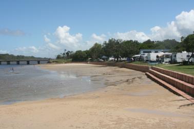
Mooball Creek at the Pottsville Caravan Park

The beach at Woody Head
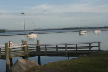
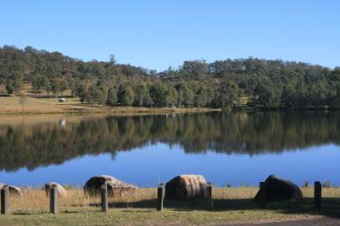
Looking across the Clarence River from our site at Iluka
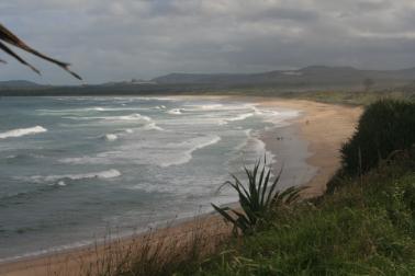
The view of Corindi Beach from our site
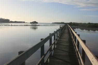
The boardwalk from the Urunga Caravan Park out to the ocean
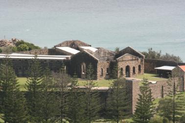
Trial Bay Gaol
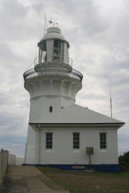
Smokey Cape Lighthouse
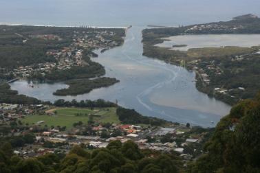
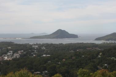
North Haven & Laurieton from North Brother Mountain Lookout
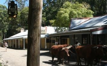
A bullock team at Timbertown Wauchope
Grant's Head and Grant's Beach at North Haven
Main Beach Port Macquarie
Tacking Point Lighthouse at Port Macquarie
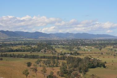
Gloucester from Kia Ora Lookout
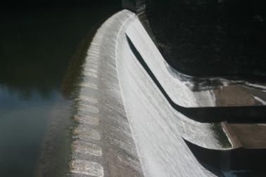
Chichester Dam full to the top!
The Headlands of Port Stephens
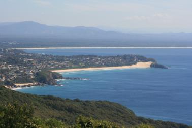
Looking towards Tuncurry from Forster
Forsters One Mile Beach from Cape Hawke Lookout
Hawks Nest Beach
Jimmy's Beach and Hawks Nest Beach from Yacaaba Lookout
Cessnock from Bimbadeen Lookout
The view from our site at Lake Glenbawn
The afternoon sun in Nundle
The Peel River in Nundle
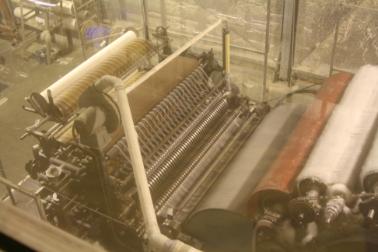
The working wool mill in Nundle
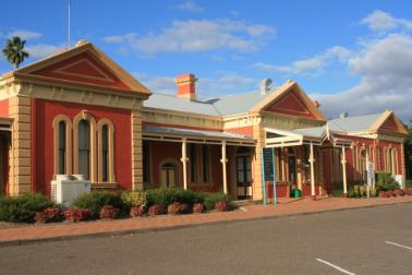
Tamworth Railway Station
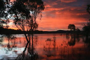
Sunset over Copeton Dam
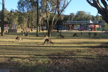
Kangaroos at one of the day use areas at Copeton Dam
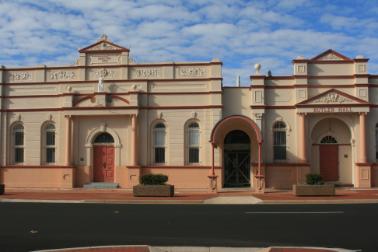
One of the many Historical Buildings in Inverell
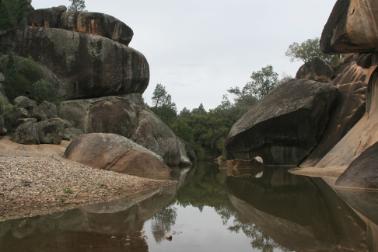
The creek at Cranky Rock Nature Reserve
The Dumaresq River at Bonshaw Weir
Quart Pot Creek and the park in Stanthorpe
Our site at Leslie Dam
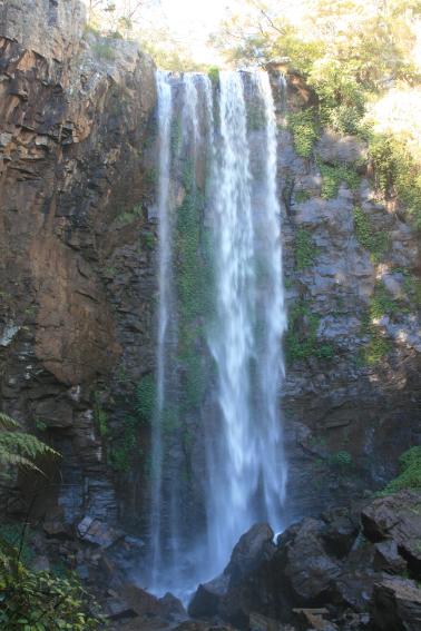
Queen Mary Falls
Cressbrook Dam